|
Home
Regions
Planning & Info
RVing Archeology
Articles
Road Logs Insurance Photos Mexico News Ontheroadin |

|
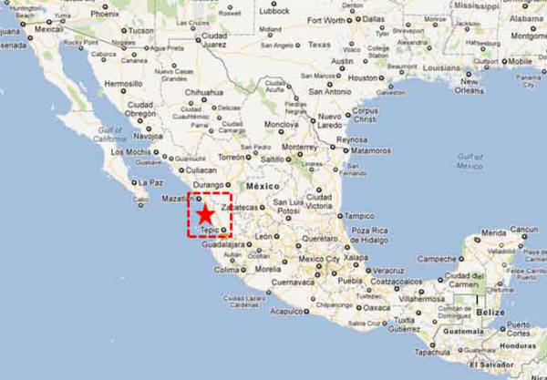
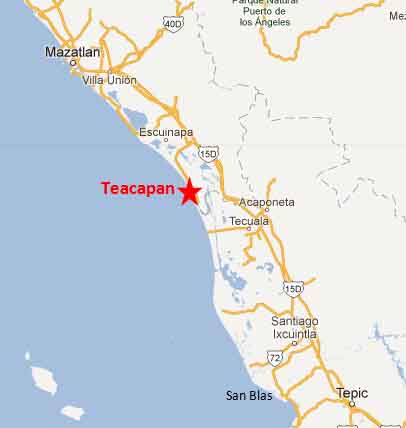
“Remembering Teopán” Teacapán Fast Facts Location – On the Pacific Coast of Mexico South of Mazatlan in the state of Sinaloa. On the mouth of the estuary. Weather - The weather is pleasant from November to May. July to September it is hot and humid with an intense rainy season in these months. Population – 4040 Elevation – Sea Level Medical – Nearest medical is in Escuinapa Money – No Banks Airport – No Airport. Nearest airport is Mazatlan. History: Teacapán is a small fishing village. Oral tradition has it that a group of Mayans called the Quiches were banished from El Salvador in about 2200 BC because of intermarriage and birth defects and sailed north and founded Teacapán. They named it Teacapahe and the “ka” sound in the middle Teacapán means 'to remember'. Hence the name Teacapán means “remembering Teopan” which was a settlement in their homeland. History changes. Fast forward June 17, 1870. A Mexican Steamer flying under a Salvadorian flag with 120 to 200 men of various nationalities (including American and Mexican) attacked the Guaymas Customs House and robbed the foreign residents, The pirate ship also made off with 200 lbs of coal. The USS Mohican was dispatched to destroy the pirate attacks off Mazatlan and followed the Forward to the Teacapán Estuary. Here the Battle of Teacapán took place; the US were victorious and the pirate steamer was sunk. Again the fish village returned to a peaceful outpost. The 1990’s saw numerous small scale tourism. A few RV parks and small hotels. If all plans go through this will change forever. The Federal Mexican government has made announcements that the area is slated for development. This Mega resort is supposed to become double the size of Cancun. Things to See and Do Birding, horseback riding, beach combing, fishing. Accommodation: Hotels RV Parks Onac RV Park Punta Hermosa Directions: Take Highway 15 south of Mazatlan. Get on the non-toll Road and take the turnoff to Escuinapa. Teacapán will be well signed; 41 kms from the highway.
|
Back to Mexico's West Coast Cities, Towns, Pueblos
*
|
|
What You Should Consider for Your Visit
|
|


On the Road In - Mexico
editor@ontheroadin.com